Week 1: Plate Boundaries & Seismic Patterns
Grade 7 Science | Rosche
MS-ESS2-2 Earth's Systems
The Phenomenon: The Earthquake Pattern Mystery
Anchoring Context & Focus Question
Why do earthquakes happen in the same places over and over?


Before We Begin: Activate Your Prior Knowledge
Think back to Cycle 5: You learned how convection drives air mass movement — warm air rises, cool air sinks, creating wind patterns. Now ask yourself: If convection moves air in the atmosphere, could the same process move solid rock deep inside Earth? Keep this question in mind as you investigate today.
Look at a map of every earthquake on Earth from the last 30 years. Thousands happen every day — but they don't happen everywhere. Instead, they form clear lines and clusters.
- The "Ring of Fire" around the Pacific Ocean has 90% of all earthquakes.
- A zigzag line of quakes runs down the middle of the Atlantic Ocean floor.
- A band of earthquakes stretches from the Mediterranean to the Himalayas.
- Large areas of continents — like the middle of Africa or Australia — have almost none.
St. Louis Connection
St. Louis sits near the New Madrid Seismic Zone — one of the most active earthquake zones EAST of the Rockies. In 1811–1812, a series of magnitude 7+ earthquakes near New Madrid, Missouri literally reversed the flow of the Mississippi River and rang church bells in Boston. Scientists predict a 25–40% chance of a magnitude 6+ quake here in the next 50 years.
Why This Matters to YOU
Understanding where and why earthquakes happen saves lives. Seismologists, earthquake engineers, and urban planners use plate tectonic knowledge to build safer buildings and create early warning systems. These are high-demand STEM careers that directly protect communities.
Focus Question: Why do earthquakes happen in the same places over and over — and what does this reveal about Earth's hidden structure?
By the end of this lesson, you will be able to:
- Explain how convection in the mantle drives plate movement.
- Identify the three types of plate boundaries and their features.
- Connect plate boundary type to earthquake and volcanic patterns.
- Apply understanding to earthquake engineering challenges.
NGSS 3D Standards
This Week's Standards
MS-ESS2-2: Construct an explanation based on evidence for how geoscience processes have changed Earth's surface at varying time and spatial scales.
Spiral Standards (Review)
- MS-ESS2-5: Air mass convection and weather patterns (Cycle 5)
- MS-ESS3-3: Human impact on Earth systems (Cycle 4)
Cognate Strategy: Many science words look similar in English and Spanish — use your Spanish to learn science!
| Term | Spanish | Definition |
|---|---|---|
| mantle | manto | Thick layer of hot rock between Earth's crust and core |
| lithosphere | litosfera | Rigid outer layer of Earth including crust and upper mantle |
| asthenosphere | astenosfera | Partially molten layer beneath the lithosphere that allows plates to move |
| convection cell | celda de convección | Circular movement of material: hot rises, cools, sinks, heats, repeats |
| tectonic plate | placa tectónica | Large, rigid section of lithosphere that moves on the asthenosphere |
| plate boundary | límite de placa | Location where two tectonic plates meet |
| earthquake | terremoto | Sudden shaking of the ground caused by movement along plate boundaries |
Hook – The Earthquake Pattern Mystery
Observe earthquake clustering patterns and generate hypotheses about why they occur where they do.
The Challenge
What You'll Do
- Examine a USGS earthquake map showing the last 30 days of global earthquakes
- Identify the pattern: where do earthquakes cluster?
- Make predictions about WHY they cluster in those specific locations
- Connect to Cycle 5: How is atmospheric convection related to what's happening inside Earth?
The Mystery Data
Scientists track every earthquake on Earth. Here's what 35 years of data reveals:
| Region | Earthquakes/Year | Pattern |
|---|---|---|
| Ring of Fire (Pacific) | ~15,000 | Dense ring around Pacific Ocean |
| Mid-Atlantic Ridge | ~3,000 | Zigzag line down ocean floor |
| Alpine-Himalayan Belt | ~5,000 | Band from Spain to Indonesia |
| Central Australia | ~5 | Almost none |
Key Question: Central Australia and the Ring of Fire are both on Earth's surface. Why does one get 15,000 earthquakes per year and the other gets 5?
Stop & Think
Before you open the form below, formulate your hypothesis: What is beneath the earthquake lines that causes them to cluster there?
Worked Example and Simulation – Identifying Plate Boundaries from Earthquake Data
The Problem
Scenario: A scientist gives you a map showing earthquake locations, volcano locations, and ocean trench locations. She asks: "Can you find the plate boundaries just from this data — without being told where they are?" Use the patterns in the data to identify boundary locations and types.

Step-by-Step Solution
Step 1: Find lines of earthquake clusters
"Earthquakes form clear lines on the map. These lines must mark where plates meet — plate boundaries. The Ring of Fire forms a nearly complete circle around the Pacific."
Step 2: Look at what features exist at each boundary
"Where I see ocean trenches + volcanoes + deep earthquakes = convergent boundary (plates pushing together). Where I see mid-ocean ridges + shallow earthquakes = divergent boundary (plates pulling apart)."
Step 3: Check for transform boundaries
"Where I see earthquakes but NO volcanoes and NO trenches = transform boundary (plates sliding past each other). The San Andreas Fault in California is a perfect example."
Now YOU Complete Steps 4-5:
Step 4: The Himalayas have earthquakes but are NOT near any ocean. What type of boundary created these mountains? What's different about this convergent boundary?
Step 5: Why are there almost NO earthquakes in the middle of the Australian plate? What does this tell us about what causes earthquakes?
Fading Support: Steps 4 and 5 are YOUR turn. This builds your plate boundary identification skills before the stations.
Now explore the boundaries yourself — Plate Boundary Simulator
Set plate motion (convergent/divergent/transform) and observe the resulting earthquake patterns, volcanism, and topography. Use the simulator data to answer Station 1's prediction questions.
Station 1 – Convection & Plate Movement
Connect heat transfer to plate motion mechanism.
Your Mission
Investigate how heat from Earth's interior creates convection currents that drive plate movement. You'll connect what you learned about atmospheric convection in Cycle 5 to a much deeper, slower version happening in Earth's mantle.
Reference Data: Earth's Interior
| Layer | Depth (km) | Temperature | State |
|---|---|---|---|
| Crust | 0–35 | ~20°C surface | Solid (rigid) |
| Lithosphere | 0–100 | ~500°C | Solid (rigid) |
| Asthenosphere | 100–660 | ~1,300°C | Plastic solid (flows) |
| Lower Mantle | 660–2,900 | ~3,000°C | Solid (high pressure) |
| Outer Core | 2,900–5,100 | ~5,000°C | Liquid iron |
| Inner Core | 5,100–6,371 | ~6,000°C | Solid iron |
Stop & Think: Predict-Observe-Explain
PREDICT: In Cycle 5 you saw warm air rise and cool air sink. If Earth's core is 6,000°C and the surface is 20°C, what do you think happens to the hot mantle rock near the core?
Station 2 – Plate Boundary Analysis
Classify boundaries, predict geological features.
Your Mission
Classify the three types of plate boundaries and predict what geological features each one creates. Use the reference data below to match boundary types to real-world examples.
Reference Data: Plate Boundary Types
| Type | Motion | Features Created | Example |
|---|---|---|---|
| Divergent | Pulling apart | Mid-ocean ridges, rift valleys, new crust | Mid-Atlantic Ridge |
| Convergent | Pushing together | Mountains, trenches, volcanoes, subduction | Andes, Himalayas |
| Transform | Sliding past | Earthquakes, fault lines (no volcanoes) | San Andreas Fault |
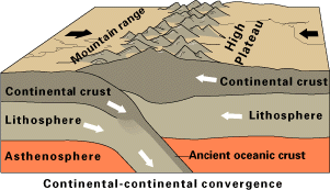
Stop & Think
The Ring of Fire has BOTH earthquakes and volcanoes. The San Andreas Fault has earthquakes but NO volcanoes. What's different about their boundary types that explains this?
Station 3 – Design an Earthquake-Resistant Structure
Apply boundary knowledge to engineering challenge.
Engineering Challenge
Apply your understanding of plate boundaries to a real-world engineering problem: designing a building that can survive an earthquake on the San Andreas Fault (transform boundary).
Design Constraints
- Location: San Francisco (transform boundary — horizontal shaking)
- Budget: $2 million construction
- Building: 10-story office building
- Must withstand: Magnitude 7.0 earthquake
Available Earthquake-Resistant Features
| Feature | Cost | Effectiveness | Trade-off |
|---|---|---|---|
| Base isolators | $300k | High | Expensive installation |
| Moment-resisting frame | $400k | Medium-high | Limits floor plan flexibility |
| Shear walls | $200k | Medium | Limits window placement |
| Cross-bracing | $150k | Medium | Visible in design |
| Dampers | $250k | High | Ongoing maintenance |
Stop & Think
Transform boundaries produce mainly HORIZONTAL shaking. How should this influence your design choices differently than if you were building near a convergent boundary (which produces both vertical and horizontal shaking)?
Exit Ticket – Plate Dynamics Integration
Synthesize learning about plate boundaries and seismic patterns.
Exit Ticket Structure
- 2 NEW questions — Today's content (plate boundaries & seismic patterns)
- 2 SPIRAL questions — Review from Cycle 5 (convection, air masses) and Cycle 4 (human impact)
- 1 INTEGRATION + SEP — Connect plate tectonics to prior learning using SEP-6 (Constructing Explanations)
Stop & Think Before You Submit
For the integration question, think about the BIG PICTURE: How does understanding plate boundaries help explain BOTH earthquake patterns AND the long-term changes to Earth's surface? Connect today's learning to what you already know.
Autonomy Support
You've now analyzed earthquake data, connected convection to plate movement, classified boundaries, and applied engineering thinking. The exit ticket checks if you can put it ALL together. Trust what you've learned today!
Enrichment & Extension
Optional content if you finish early or want to go deeper.

Scientist Spotlight: Inge Lehmann
Inge Lehmann (1888–1993) was a Danish seismologist who discovered that Earth has a solid inner core inside its liquid outer core. In 1936, she analyzed seismic waves from earthquakes and noticed that some waves arrived where they shouldn't — unless they bounced off a hidden solid layer deep inside Earth. Her discovery, known as the Lehmann discontinuity, revolutionized our understanding of Earth's interior. She worked in a field dominated by men and once said her success was partly because "ichthyologists and gardeners and diplomats" didn't question her data the way male seismologists might have.
Environmental Justice: Earthquake Preparedness Inequality
Earthquakes don't discriminate, but their damage does. The 2010 Haiti earthquake (magnitude 7.0) killed over 200,000 people, while the 2010 Chile earthquake (magnitude 8.8 — 500 times more energy) killed 525. The difference? Building codes, infrastructure investment, and emergency systems. Low-income communities and developing nations suffer disproportionately because they lack resources for earthquake-resistant construction. In the US, older buildings in low-income neighborhoods are often not retrofitted to modern seismic standards, putting residents at higher risk even in earthquake-prone cities like Los Angeles and Memphis (near our own New Madrid zone).
Week 1 Complete!
Next Week: Seafloor Spreading & Continental Drift — how do we know continents moved?