Week 2: Seafloor Spreading & Continental Drift
Grade 7 Science | Rosche
MS-ESS2-3 Earth's Systems
The Phenomenon: The Underwater Mountain Mystery
Anchoring Context & Focus Question
How can mountains exist on the ocean floor?


Before We Begin: Activate Your Prior Knowledge
Think back to Week 1: You learned that divergent boundaries are where plates pull apart. Now ask yourself: If plates are pulling apart at the Mid-Atlantic Ridge, what fills the gap? And if new material is constantly being added, why isn't Earth getting bigger? Keep these questions in mind as you investigate today.
Deep beneath the Atlantic Ocean lies a mountain range taller than anything on land. The Mid-Atlantic Ridge rises 2-3 km above the ocean floor and stretches from Iceland to Antarctica.
- New molten rock constantly erupts along the ridge, creating fresh ocean floor.
- The newest rock is at the ridge center; the oldest is at the continent edges.
- Europe and North America move 2.5 cm apart each year — about the speed your fingernails grow.
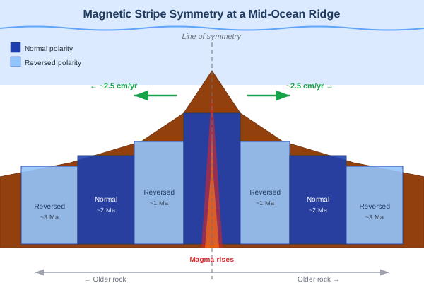
- Magnetic patterns in the rock form perfect mirror images on either side of the ridge.
St. Louis Connection
Missouri's geology tells a continental drift story. The fossils in our limestone bluffs along the Mississippi — ancient sea creatures, crinoids, brachiopods — formed when Missouri was near the equator, covered by a shallow tropical sea over 300 million years ago. Plate tectonics moved our region thousands of miles north to our current latitude.
Why This Matters to YOU
Understanding seafloor spreading helps scientists predict volcanic eruptions, find mineral deposits, and even locate new sources of renewable geothermal energy. Oceanographers and marine geologists explore these underwater frontiers — careers that combine adventure with cutting-edge science.
Focus Question: How can mountains exist on the ocean floor — and what do they reveal about Earth's moving plates?
By the end of this lesson, you will be able to:
- Interpret magnetic stripe evidence for seafloor spreading.
- Use multiple lines of evidence to support continental drift.
- Explain how spreading and subduction recycle Earth's crust.
- Design systems to detect and measure plate movement.
NGSS 3D Standards
This Week's Standards
MS-ESS2-3: Analyze and interpret data on the distribution of fossils and rocks, continental shapes, and seafloor structures to provide evidence of past plate motions.
Spiral Standards (Review)
- MS-ESS2-2: Plate boundaries and seismic patterns (Week 1)
- MS-ESS2-5: Convection and weather patterns (Cycle 5)
Cognate Strategy: Many science words look similar in English and Spanish — use your Spanish to learn science!
| Term | Spanish | Definition |
|---|---|---|
| magnetic reversal | inversión magnética | When Earth's magnetic poles switch direction |
| polarity | polaridad | The direction of a magnetic field (normal or reversed) |
| spreading rate | tasa de expansión | Speed at which new seafloor is created at mid-ocean ridges |
| mid-ocean ridge | dorsal oceánica | Underwater mountain chain where new seafloor forms |
| seafloor spreading | expansión del fondo oceánico | Process of creating new oceanic crust at mid-ocean ridges |
| symmetry | simetría | Balanced pattern on both sides of a mid-ocean ridge |
| evidence | evidencia | Scientific observations and data that support a claim |
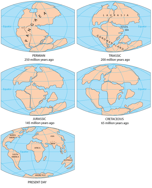
| continental drift | deriva continental | The theory that Earth's continents were once joined and have slowly moved apart over millions of years |
| Pangaea | Pangea | The supercontinent that existed about 200 million years ago, before breaking apart into today's continents |
| subduction | subducción | The process where one tectonic plate slides beneath another, recycling old crust back into the mantle |
| fossil distribution | distribución de fósiles | The pattern of where specific fossil types are found across different continents, used as evidence for continental drift |
Hook – The Underwater Mountain Mystery
Explore mid-Atlantic Ridge bathymetry data.
The Challenge
What You'll Do
- Examine ocean floor bathymetry data from the Mid-Atlantic Ridge
- Observe the symmetrical pattern of the underwater mountain range
- Connect this to what you learned about divergent boundaries in Week 1
- Predict what process creates these underwater mountains
The Mystery Data
Scientists measured the age of rocks on the ocean floor at different distances from the Mid-Atlantic Ridge:
| Distance from Ridge | Rock Age (West) | Rock Age (East) |
|---|---|---|
| 0 km (at ridge) | Brand new | Brand new |
| 500 km | 20 million years | 20 million years |
| 1,500 km | 60 million years | 60 million years |
| 3,000 km (near coast) | 180 million years | 180 million years |
Key Question: Notice the SYMMETRY — rocks the same distance from the ridge are the same age on BOTH sides. What process could create this perfect mirror pattern?
Stop & Think
Before you open the form: If the newest rock is at the center and the oldest is at the edges, what must be happening at the ridge? Think of a conveyor belt...
Worked Example and Simulation – Interpreting Magnetic Stripe Patterns
The Problem
Scenario: Scientists measure the magnetic field direction recorded in ocean floor rocks. They discover alternating stripes of "normal" polarity (like today's field) and "reversed" polarity (opposite direction). The stripes form a symmetric pattern on both sides of the ridge. Interpret what these stripes mean.

Step-by-Step Solution
Step 1: Read the pattern at the ridge center
"The youngest rock at the ridge center shows NORMAL polarity — matching today's magnetic field. This lava just cooled recently."
Step 2: Move outward from the center
"The next stripe shows REVERSED polarity. This rock formed during a time when Earth's magnetic field was flipped. The stripe after that is normal again. It alternates! And the pattern is a MIRROR IMAGE on both sides of the ridge."
Step 3: Explain the symmetry
"The mirror image proves the rock formed at ONE point (the ridge) and split in two directions. Like tearing a page in half — both sides have the same pattern reversed."
Now YOU Complete Steps 4-5:
Step 4: If the spreading rate is 2.5 cm/year, how old is a stripe 50 km from the ridge? Show your math.
Step 5: Why is this evidence STRONGER than just saying "the continents look like they fit together"?
Fading Support: Steps 4 and 5 are YOUR turn. This builds your evidence-interpretation skills before Station 1.
Now reassemble Pangaea yourself — Pangaea Puzzle Simulator
Drag continents back together using fossil, climate, and coastline-match evidence. Use what you learn here to answer Station 1's evidence-strength questions.
Station 1 – Seafloor Spreading Evidence
Interpret magnetic evidence for seafloor spreading.

Your Mission
Analyze magnetic stripe data from the ocean floor to determine the rate and direction of seafloor spreading. You'll measure stripe widths, calculate spreading rates, and use the symmetry pattern as evidence that new crust forms at mid-ocean ridges.
Reference Data: Magnetic Stripe Measurements
| Stripe # | Polarity | Width (km) | Age Range (Ma) |
|---|---|---|---|
| 1 (center) | Normal ↑ | 20 | 0–0.78 |
| 2 | Reversed ↓ | 25 | 0.78–2.58 |
| 3 | Normal ↑ | 15 | 2.58–3.60 |
Stop & Think: Predict-Observe-Explain
PREDICT: If you measured magnetic stripes 500 km east of the ridge and 500 km west, would the patterns match? Why or why not?
Station 2 – Pangaea Puzzle Investigation
Multiple lines of evidence for continental drift.
Your Mission
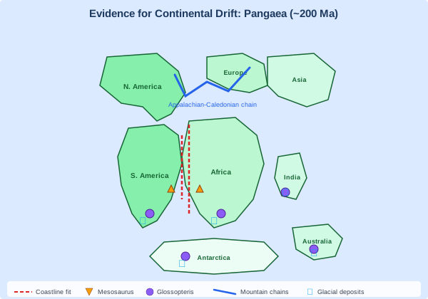
Use multiple lines of evidence — fossils, rock types, climate clues, and coastline shapes — to reconstruct the supercontinent Pangaea and evaluate the strength of converging evidence.
Evidence Summary
| Evidence Type | What It Shows | Continents Connected |
|---|---|---|
| Mesosaurus fossils | Freshwater reptile on both coasts | South America + Africa |
| Glossopteris fern | Same plant fossil on 5 continents | S. America + Africa + India + Antarctica + Australia |
| Glacial striations | Ice scratch marks in tropical locations | India, Africa, S. America near equator |
| Mountain chains | Appalachians match Scottish Highlands | North America + Europe |
Stop & Think
Mesosaurus was a FRESHWATER reptile that couldn't survive in salt water. Its fossils appear on both sides of the Atlantic. What's more likely: (a) it swam 5,000 km across the ocean, or (b) the continents were once connected? Why is this evidence so powerful?
Station 3 – Design a Plate Movement Detector
Apply understanding to measurement challenge.
Engineering Challenge
Design a system that could detect and measure the movement of tectonic plates in real time. Plates move only 1-10 cm per year — how would you measure something that slow?
Real Detection Methods
| Technology | How It Works | Precision |
|---|---|---|
| GPS stations | Satellites measure ground position changes | ±1 mm/year |
| Laser ranging | Laser beams measure distance between stations | ±5 mm/year |
| Seismometers | Detect vibrations from sudden plate slips | Detects M1.0+ |
Stop & Think
GPS can measure plate movement to within 1 mm/year. But in 1912, Alfred Wegener proposed continental drift with NONE of this technology. What evidence did he use instead, and why did most scientists reject his idea for 50 years?
Exit Ticket – Earth's Dynamic Surface Integration
Synthesize evidence for seafloor spreading and continental drift.
Exit Ticket Structure
- 2 NEW questions — Today's content (seafloor spreading & continental drift evidence)
- 2 SPIRAL questions — Review from Week 1 (plate boundaries) and Cycle 5 (convection)
- 1 INTEGRATION + SEP — Connect seafloor spreading to plate boundaries using SEP-4 (Analyzing & Interpreting Data)
Stop & Think Before You Submit
For the integration question: How does seafloor spreading at divergent boundaries CONNECT to the earthquake patterns you mapped in Week 1? Think about the complete plate cycle — new crust created at ridges, destroyed at subduction zones.
Autonomy Support
You've now analyzed magnetic stripes, reconstructed Pangaea from fossil evidence, and explored real plate detection technology. You have multiple lines of evidence — use them to build strong scientific arguments!
Enrichment & Extension
Optional content if you finish early or want to go deeper.

Scientist Spotlight: Marie Tharp
Marie Tharp (1920–2006) was an American geologist who created the first comprehensive maps of the ocean floor. In the 1950s, women weren't allowed on research ships, so she analyzed sonar data from shore while her colleague Bruce Heezen collected it at sea. She discovered a massive rift valley running down the center of the Mid-Atlantic Ridge — direct evidence of seafloor spreading. When she first proposed it, Heezen dismissed it as "girl talk." She persisted, and her maps eventually proved continental drift was real, transforming geology forever.
Environmental Justice: Deep-Sea Mining
The same mid-ocean ridges that create new seafloor also deposit valuable minerals — manganese, cobalt, and rare earth elements — in "nodules" on the ocean floor. Companies now want to mine these deposits for electric vehicle batteries and smartphones. But deep-sea mining could destroy unique ecosystems that took millions of years to develop. The International Seabed Authority debates who benefits: wealthy nations with mining technology, or Pacific Island nations whose waters and fisheries would be disrupted. Understanding plate tectonics helps us weigh the costs of extracting resources from the very processes that shape our planet.
Week 2 Complete!
Next Week: Volcanic Eruption Styles & Magma Properties — why do some volcanoes explode?