Week 1: Rock Types & the Rock Cycle
Grade 7 Science | Rosche
MS-ESS2-1 Earth's Systems
The Phenomenon: The Mountaintop Seashell Mystery
Anchoring Context & Focus Question
How can you find seashells on top of a mountain?
Cognate Strategy: Many science words look similar in English and Spanish — use your Spanish to learn science!
| Term | Spanish | Definition |
|---|---|---|
| igneous rock | roca ígnea | Rock formed from cooled magma or lava |
| sedimentary rock | roca sedimentaria | Rock formed from compressed layers of sediment |
| metamorphic rock | roca metamórfica | Rock changed by heat and pressure |
| rock cycle | ciclo de rocas | Continuous process of rock formation and transformation |
| weathering | meteorización | Breaking down of rocks by wind, water, ice, and living things |
| uplift | levantamiento | The rising of Earth's crust, often due to plate tectonic forces, exposing buried rocks |
Hook – The Mountaintop Seashell Mystery
Examine fossil evidence from mountain peaks and generate hypotheses about how ocean organisms ended up at high elevations.
The Mountaintop Seashell Mystery
Scientists climbing Mount Everest found marine fossils (trilobites, brachiopods, crinoids) embedded in limestone — 29,000 feet above sea level. These organisms lived in an ancient ocean over 450 million years ago. How did creatures from the sea end up on top of the world's tallest mountain?
Cycle 6 Connection
What You'll Do
- Examine fossil and rock evidence from the Himalayas
- Retrieve what you already know about plate tectonics (Cycle 6)
- Predict how three rock types might be connected
- Submit your reasoning — no wrong answers yet, just your best thinking
Worked Example – Classifying Rocks by Formation Process
Worked Example: Classifying Rocks by Formation Process
Problem: A geologist gives you three hand samples — a rock with visible crystal grains, a rock with stacked sandy layers and a fossil, and a rock with wavy banded stripes. She asks: "Which is igneous, sedimentary, or metamorphic — and how do you know?"
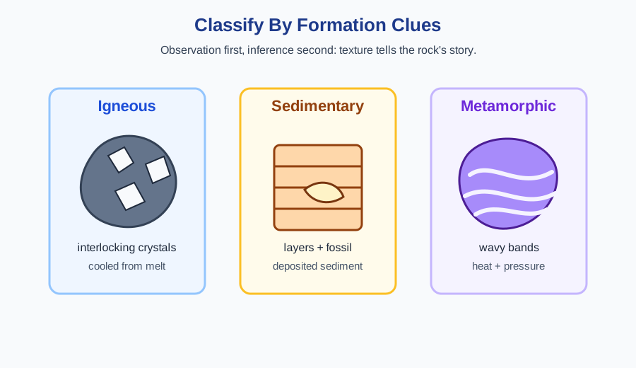
Step 1: Look for Formation Clues
- Crystals interlocked (no layers, no fossils) → cooled from melt → IGNEOUS
- Layers + particles + fossils → deposited and compressed → SEDIMENTARY
- Bands, foliation, or stretched minerals → heat + pressure changed it → METAMORPHIC
Step 2: Connect to the Rock Cycle
Station 1 – Rock Classification Lab
Classify rocks by formation process and identify igneous, sedimentary, and metamorphic types.
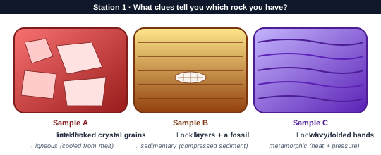
Station 1 — Rock Classification Lab
Your mission: classify 8 rock samples using the observation → inference → formation process workflow you saw in the worked example. You'll use texture, mineral composition, and structural clues (layers, bands, crystals) to place each sample in the correct rock-cycle family.
Evidence Checklist
Station 2 – Rock Cycle Modeling
Model transformations between rock types through the rock cycle.
Station 2 — Tracing Materials Through the Rock Cycle
Follow a single calcium carbonate molecule on a 200-million-year journey: from a shell in a shallow sea → limestone on the ocean floor → marble in a mountain range → sand in a river → back to a reef. You'll use a rock-cycle diagram to predict each transformation and the process that drives it.
Processes to Track
- Weathering/erosion — breaks rock into sediment
- Deposition + compaction + cementation — forms sedimentary rock
- Heat + pressure — metamorphism (no melting!)
- Melting + cooling — creates new igneous rock
Station 3 – Design a Rock Formation Timeline
Apply rock cycle understanding to create explanations for formation sequences.
Station 3 — Evidence of the Rock Cycle in Missouri
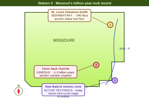
The St. Louis area sits on 340-million-year-old limestone from an ancient inland sea. The Ozark Mountains to the southwest show rhyolite (igneous) and metamorphic rocks from even older events. Your task: use USGS data and rock samples to reconstruct Missouri's rock-cycle history.
Local Evidence to Analyze
- St. Louis limestone bluffs — sedimentary evidence of the Paleozoic sea
- Taum Sauk Mountain rhyolite — 1.5-billion-year-old volcanic rock
- New Madrid seismic zone — ongoing tectonic activity that could recycle today's rock
Argument from Evidence
Exit Ticket – Rock Cycle Integration
Synthesize learning about rock types and the rock cycle.
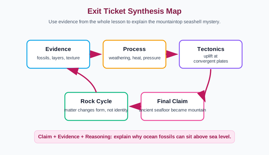
Exit Ticket — Rock Cycle Mastery
Demonstrate your understanding of the rock cycle through 2 new-content questions, 2 spiral questions from Cycle 6 (plate tectonics drives the rock cycle!), and 1 integration question that connects rocks, plates, and the SEP practice of constructing explanations.
Enrichment & Extension
Optional content if you finish early or want to go deeper.
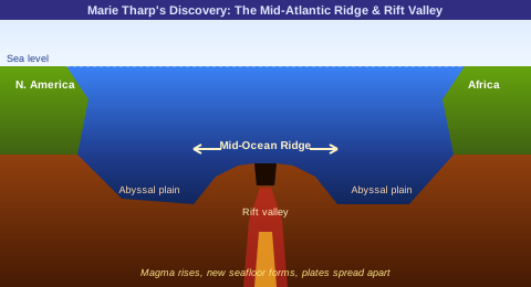
Scientist Spotlight: Marie Tharp
Marie Tharp (1920–2006) was an American oceanographer and geologist who spent 18 years hand-drafting the first detailed map of the Atlantic Ocean floor. At a time when women were barred from research ships, Tharp worked from sonar depth readings in a lab at Columbia University. Her map revealed a mid-ocean ridge with a deep central rift valley running the length of the Atlantic — direct evidence that the seafloor was spreading and continents were moving. Her discovery proved the theory of plate tectonics and helps us explain today's phenomenon: seashells end up on mountaintops because ancient seafloor gets pushed upward when tectonic plates collide over millions of years. Rocks you hike across in the Rockies or Appalachians were once buried under an ocean.
Environmental Justice: Coldwater Creek, St. Louis
The rock cycle carries more than minerals — it also moves radioactive isotopes through sediment, water, and soil. During World War II, Mallinckrodt Chemical processed uranium ore in north St. Louis to build the first atomic bombs. Radioactive waste was stored in barrels near the airport and leaked into Coldwater Creek, which flows through predominantly Black and working-class neighborhoods in Florissant, Hazelwood, and Berkeley. Decades of flooding carried contaminated sediment into yards, schools, and playgrounds. Residents who grew up along the creek now have unusually high rates of rare cancers. Scientists studying sedimentary rock layers and soil samples are mapping where the contamination traveled — the same weathering and deposition processes you're learning this week are what spread the harm, and what cleanup crews now race to reverse.
Week 1 Complete!
Next Week: Geologic Time & Fossil Evidence — how do we know what Earth looked like millions of years ago?