Week 2: Geologic Time & Fossil Evidence
Grade 7 Science | Rosche
MS-ESS1-4 Earth's Place in the Universe
The Phenomenon: The Deep Time Mystery
Anchoring Context & Focus Question
How do we know what Earth looked like millions of years ago?
Cognate Strategy: Many science words look similar in English and Spanish — use your Spanish to learn science!
| Term | Spanish | Definition |
|---|---|---|
| stratigraphy | estratigrafía | Study of rock layers and their sequence |
| superposition | superposición | Law that younger layers are on top of older layers |
| index fossil | fósil índice | Fossil used to identify and date rock layers |
| geologic time scale | escala de tiempo geológico | Timeline dividing Earth's 4.6 billion year history |
| relative dating | datación relativa | Determining if something is older or younger without exact age |
| extinction | extinción | Complete disappearance of a species |
| sediment | sedimento | Small particles of rock, minerals, or organic material |
Hook – The Deep Time Mystery
Compare the geologic time scale to human history and generate hypotheses about how scientists reconstruct Earth's past.
The Deep Time Mystery
Earth is 4.6 billion years old — a number so large it's hard to imagine. If Earth's entire history were compressed into one calendar year, humans would appear in the last 11 seconds of December 31st. Geologists read this enormous story by studying rock layers, fossils, and the law of superposition: the deeper the layer, the older it is. Missouri's own limestone bluffs along the Mississippi River record 300 million years of history right here in St. Louis.
Cycle 7 Week 1 Connection
What You'll Do
- Examine the geologic time scale and place major events on a proportional timeline
- Apply the law of superposition to read rock layer sequences
- Use index fossils to match and date rock layers from different locations
- Analyze the fossil record to identify mass extinction events
- Submit your reasoning about how we reconstruct Earth's past
Worked Example – Reading Rock Layers Using Superposition
Worked Example and Simulation: Reading Rock Layers Using Superposition
Problem: A geologist exposes a cliff face in rural Missouri with five visible rock layers. Layer A is at the bottom, Layer E is at the top. Layer A contains trilobite fossils. Layer C contains dinosaur tracks. Layer E contains modern plant pollen. She asks: "What is the age order of these layers, and what can the fossils tell us about when each layer formed?"
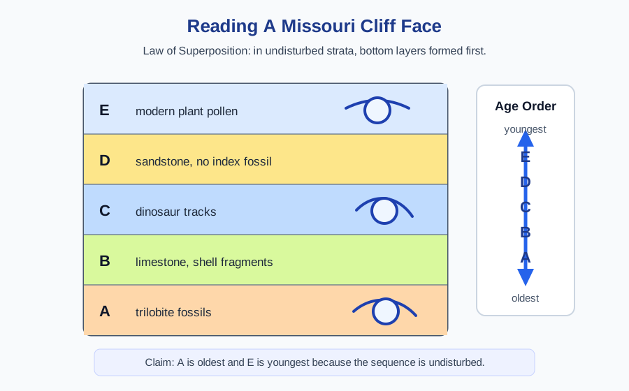
Step 1: Apply the Law of Superposition
Step 2: Use Index Fossils to Add Dates
Step 3: Watch for Gaps (Unconformities)
Simulation: Geologic Time
PREDICT (before)
Look at the simulation controls. Before changing any variables, predict what will happen when you adjust them. Write your prediction down.
OBSERVE (during)
Change one variable at a time. Record what happens after each change. Use the data journal to capture at least 3 trials.
EXPLAIN (after)
Compare your observations with your prediction. Use scientific vocabulary to explain the patterns you found. What surprised you? What confirmed your thinking?
Station 1 – Stratigraphy Investigation
Use superposition and index fossils to determine the relative ages of rock layers.
Station 1 — Stratigraphy Investigation
You are a geologist studying two sediment cores drilled 50 miles apart in Missouri — one near St. Louis, one near the Ozarks. Both cores show multiple rock layers. Your task: use the Law of Superposition and index fossils to match layers between the two cores and determine their relative ages. This is the same technique scientists used to map Earth's rock record long before radiometric dating existed.
Evidence Checklist — For Each Rock Layer
- Position: Is this layer near the top (younger) or bottom (older) of the core?
- Index fossil present? If yes, record the fossil name and its known time range
- Relative age claim: Write a statement comparing this layer to adjacent layers (e.g., "Layer B is older than Layer C because it is below it")
- Correlation: Does a matching index fossil appear in the other core? If so, those layers are the same age
Station 2 – Fossil Record Analysis
Interpret fossil distribution patterns and identify major extinction events.
Station 2 — Reading the Fossil Record
The fossil record is not evenly distributed — some layers are packed with diverse species; others show a sudden collapse. These collapses are mass extinction events (extinciones masivas). Scientists count the number of species in each rock layer period and plot it over time to find these patterns. You will analyze a simplified fossil diversity chart and answer analytical questions about what the data reveals.
Patterns to Identify
- Locate two major extinction events in the diversity chart — identify the era boundary where each occurs
- Recovery pattern: After each extinction, how long did it take for diversity to recover? Compare the two events
- Geologic Time Scale placement: Label each extinction event on the provided time scale with the correct era transition (e.g., Permian–Triassic, Cretaceous–Paleogene)
- Modern connection: How does current species loss compare to historical extinction rates? Use the chart data to support your argument
Station 3 – Design a Geologic Investigation
Apply dating principles to solve an age determination problem with unknown strata.
Station 3 — Design a Geologic Investigation
You have discovered a new rock formation with three distinct layers. Your mission: design a complete investigation to determine the relative ages of the layers, reconstruct the ancient environment of each layer, and explain what geologic events shaped this site. This is the same work real field geologists do when they encounter an unexplored outcrop.
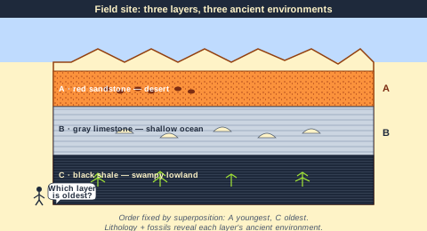
The Rock Formation: Your Field Site
- Layer A (top): Red sandstone with footprints
- Layer B (middle): Gray limestone with seashells
- Layer C (bottom): Black shale with plant fossils
Your Investigation Must Answer
- Relative ages: Which layer is oldest? Which is youngest? How do you know?
- Environments: What kind of environment did each layer form in? Use rock type and fossil clues.
- Timeline: Put layers in order from oldest to youngest and describe how this location changed over time.
- Limitations: What additional evidence would you need to get absolute (exact) ages?
- Cross-cutting: If a magma intrusion cuts through all three layers, what does that tell you?
Exit Ticket – Earth History Integration
Synthesize learning about geologic time and fossil evidence.
Exit Ticket — Earth History Integration
Demonstrate your mastery of geologic time and fossil evidence through 2 new-content questions (stratigraphy & index fossils), 2 spiral questions from prior learning (MS-ESS2-6 climate factors and Cycle 6 plate tectonics), and 1 integration question that connects rock types, geologic time, and plate tectonics using the SEP practice of constructing explanations (SEP-6).
Question Structure (23 points)
- [NEW] Q1–Q2 (8 pts): Stratigraphy & index fossil identification — this week's core content
- [SPIRAL] Q3 (8 pts): MS-ESS2-6 — distance from water and climate moderation (IXL data gap reteach)
- [SPIRAL] Q4 (8 pts): Cycle 6 — continental drift and fossil distribution as evidence
- [INTEGRATION + SEP-6] Q5 (7 pts): Construct an explanation connecting rock types, geologic time, and plate tectonics — Himalayan marine fossils scenario
Enrichment & Extension
Optional content if you finish early or want to go deeper.
Scientist Spotlight: William Smith
William Smith (1769–1839) was an English canal surveyor and self-taught geologist who created the world's first large-scale geologic map of England, Wales, and part of Scotland in 1815 — entirely on his own, without a university degree, working as a laborer. While supervising canal digs across England, Smith noticed that the same types of fossils always appeared in the same sequence of rock layers, no matter where he was. He realized that fossils could be used as clocks to identify and match rock layers hundreds of miles apart — a principle called biostratigraphy (bioestratigrafía). His colleagues in the Geological Society initially stole his ideas without credit because of his working-class background. Eventually, he was recognized and called "The Father of English Geology." His story reminds us that observational skill and persistence can produce discoveries that transform science — regardless of formal credentials.
Environmental Justice: West Lake Landfill — Reading Contamination in Layers
Just 15 miles north of our school, the West Lake Landfill in Bridgeton, Missouri contains approximately 8,700 tons of radioactive waste illegally buried in the 1970s — leftover from the same Manhattan Project uranium processing that contaminated Coldwater Creek. Geologists and environmental scientists have used the same layering principles you studied today to map exactly how deep the contamination is and how it has migrated through different soil layers over decades. Like reading rock strata, scientists drill cores, collect samples at each depth, and use the layer sequence to reconstruct when contamination reached different zones. The Bridgeton community — predominantly working-class families of color — has fought for decades to get this site cleaned up. Understanding how geologists read layers is not just an academic skill: it is a tool for accountability, environmental monitoring, and protecting communities from harm.
Week 2 Complete!
Next Week: Radiometric Dating & Absolute Age — how can scientists determine the exact age of a dinosaur bone?